
America's Landforms & Climates
The United States is a vast and geographically diverse country with a wide range of landforms and climates. These climates and subclimates are significantly influenced by these diverse landforms and play a crucial role in shaping the country’s culture and human activities.
Mountain Ranges
Mountain ranges like the Rocky Mountains, Sierra Nevada, and the Cascades act as barriers to the movement of air masses. When moist air from the Pacific Ocean encounters these mountains, it is forced to rise, cool, and release moisture on the windward (western) side.
This leads to a wetter climate on the windward slopes and a rain shadow effect on the eastern side, creating drier conditions, as seen in the Great Basin and part of the Midwest.
The Appalachian Mountains influence the climate of the eastern United States. The mountains partially shield the eastern states from the extreme cold of the interior and can influence weather patterns.
As the opposite of the mountain ranges in the western United States, the eastern slopes of these mountains receive more precipitation than the western slopes.
Coastlines
Coastal areas experience more moderate temperature due to the thermal inertia of water, which means that the water warms slowly as heat is added but also gives up that heat slowly as its surroundings cool.
Coastal regions have milder, less extreme temperature variations compared to the inland areas. The East Coast of the U.S. has a varied coastline with bays, estuaries, and barrier islands along the Atlantic Ocean.
The West Coast has a rugged coastline with cliffs, coves, and bays along the Pacific Ocean. Milder temperatures in cities such as San Francisco and Miami experience milder climates and less variation because of these coastlines.
The Gulf Coast includes a mix of marshes, swamps, and sandy beaches along the Gulf of Mexico, and plays a vital role in shaping the climate of the southeastern United States. The Gulf Coast contributes to the humid subtropical climate experience in states like Florida, Alabama, and Georgia. Warm, moist air from the Gulf fuels frequent thunderstorms and high humidity in this region.
Plains
The Great Plains is a vast, flat region in the central United States known for its agriculture and cattle ranching. This region is known for its continental climate which is influenced by its distance from large bodies of water and lacks the moderating effects of oceans and mountains. This results in the area experiencing a wide range of temperatures, with cold winters and hot summers.
The Central Valley located in California is one of the most productive agricultural regions in the United States. This area is around 400 miles long and is surrounded by the Sierra Nevada Mountains to the east and the Coastal Range to the west. This area experiences a Mediterranean climate characterized by distinctive wet and dry seasons. During the winter, the region is influenced by Pacific storm systems that bring rainfall, while during the summer, high-pressure systems lead to dry and sunny conditions.
Plateaus
Plateaus influence local climates, creating variations in temperature and precipitation. The higher elevation of plateaus can often result in cooler temperatures, and their geographical features can lead to variations in precipitation.
The Colorado Plateau encompasses parts of Arizona, Colorado, Utah, and New Mexico. The climate of the Colorado Plateau is characterized as a high desert or a semi-arid climate. This region experiences distinct seasons and relatively low precipitation. The arid climate is influenced by the rain shadow created by the Rocky Mountains that block moisture from reaching the region.
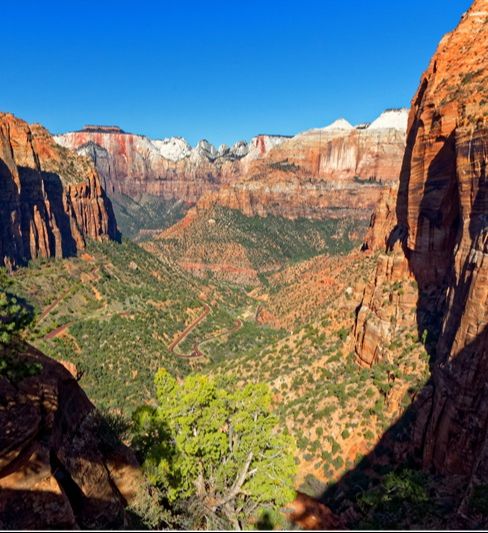
Summers are typically hot while nighttime temperatures in the winter can reach below freezing. The varied terrain here ranges from high elevation to deep canyons such the Grand Canyon, Bryce Canyon, and Zion National Park. These extremes cause varying microclimates in these distinct regions as well. In fact, climate and weather helped to shape these natural wonders over millions of years.
The Columbian Plateau is found in the Pacific Northwest in parts of Washington, Colorado, and Idaho. The climate of the Columbia Plateau is influenced by its geographical features, including its elevation, proximity to the Pacific Ocean, and the rain shadow effect created by the Cascade Mountain Range. The Columbia Plateau features a diverse geography, including rolling hills, canyons, and basalt formations.
The Columbia Plateau generally experiences a semi-arid to arid climate with distinct seasonal variations, however the diverse topography can create microclimates within the region, leading to variations in local weather and temperature. The Columbia River, which runs through the region, plays a significant role in providing water for various purposes, including agriculture and power generation.
Deserts
Deserts, like the Sonoran found in Arizona and California and the Mojave found primarily in southern California, have unique climates characterized by hot, dry summers and relatively mild winters. The surrounding geography is made up of mountain ranges and rain shadows that contribute to the arid conditions found in these regions.
Alaska
Alaska is a region of the United States that is unique. With its vast size, numerous mountain ranges, and extensive coastline, Alaska experiences a wide range of climates. The Arctic climate of the far north is influenced by its proximity to the Arctic Ocean, whereas the milder maritime climate in the coastal areas with mild, wet winters and warm, dry summers, is due to the warming effects of the ocean currents.
The United States’ diverse geography and range of climates are influenced by its vast size, varying elevations, and proximity to different bodies of water, making it a country with an array of landscapes and weather patterns. Its mountain ranges, coastlines, deserts, plains, and plateaus, all play significant roles in determining these climate patterns.